Summary: Continuing the hunt for Noah’s ark, we explore the case for the Durupinar site in extreme eastern Turkey. The 1st of a 2-part series.
For behold, I will bring a flood of waters upon the earth to destroy all flesh in which is the breath of life under heaven. Everything that is on the earth shall die. But I will establish my covenant with you, and you shall come into the ark, you, your sons, your wife, and your sons’ wives with you. And of every living thing of all flesh, you shall bring two of every sort into the ark to keep them alive with you. They shall be male and female.– Genesis 6:17-19 (ESV)
Views About the Genesis Flood Account
This week we pick up again our survey of the most popular proposals for the location of Noah’s ark with the now famous Durupinar site. Excerpts from our podcast series will be included featuring a discussion between filmmaker Timothy Mahoney and Andrew Jones from Discovered Media. Evidence for and against the site will be explored, along with stories from the investigation. Look for additional ark-location proposals to be covered in future articles as we seek evidence of one of the Bible’s most significant events.
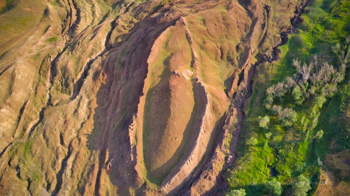
Genesis chapters 6-8 recounts how God flooded the Earth because of the evil and violence of mankind, while rescuing righteous Noah and his family (eight souls in all), and every kind of animal on a vessel called the ark. The text says the ark came to rest on the mountains of Ararat. Could the boat-shaped formation at the Durupinar site qualify as the final resting place of the ark? Let’s see what Andrew has to say in his discussion with Tim.
TIM MAHONEY: Hello, Thinkers. Boy, do we have an exciting new set of episodes for you as we continue our series, The Hunt for Noah’s ark. In our last set of episodes, we spoke with Ted Wright of Epic Archaeology about Mount Ararat in Turkey. Now though, we’re going to get into a little bit of controversy and talk about a site I’m sure most of you are familiar with. Of course, I’m referring to the Durupinar site, popularized in the 1970s and 80s by Ron Wyatt as being the remains of Noah’s ark. And here with us to discuss this location as someone who has helped us extensively with gathering footage and photos of sites in the Middle East for our films. Andrew Jones, welcome.
ANDREW JONES: Thank you, Tim, for having me on. I’m happy to share all that we’re doing out here with Noah’s ark research at this site.

TIM MAHONEY: And just so people know where you’re coming from, what is your view on the flood? Do you believe it was a global flood?
ANDREW JONES: Well, when you’re out here in the lands of the Bible, you notice things that match perfectly with the Bible, whether you look at archaeological sites or in geology. When you’re out here, you see evidence of the land being underwater right near Mount Ararat, where we’re at in the Durupinar site. You see these shallow water seashells and coral that’s been fossilized. From my view, and I believe it is a Biblical view, there was a worldwide flood that destroyed the whole world that only eight people survived. And I think that’s a view that’s held in the New Testament, by the early church, and by Christ, that this was a worldwide judgment by God. And there was only one way of salvation through the ark. And that there were not other people living in other parts of the world at the time through a local flood.
To me, it doesn’t make any sense that if God is judging the wickedness of the world, he would only destroy some people and then tell them to build an ark when they could just walk to higher ground or migrate someplace else where there’d be no flood. So in my mind, a global flood is Biblical, and you find this type of geological evidence worldwide.
Pursuing an Early Interest
TIM MAHONEY: This location was identified by Ron Wyatt, and he proposed that this was the site where Noah’s ark came to rest. So could you tell us a little bit about Ron Wyatt?
ANDREW JONES: The site was actually first found by Captain Ilhan Durupinar. That’s where we get the name, the Durupinar site. And he thought he had found Noah’s ark, but no one really listened to him. It was discovered in September 1959. And then about 20 years later, Ron Wyatt made his first trip after he had heard about it or read about it in Life Magazine in the September 5th, 1960 edition. He had a young family and didn’t have the funds to go traveling. So about 20 years later in 77, he came out there with his two teenage sons. And Ron was an adventurer, amateur archaeologist. His profession was in the medical field, but he had a strong belief in the Bible – that it was a true history of the world and that it was God’s word, and he wanted to share it with people. I met him twice and I used to talk to him on the phone a lot as a kid through middle school and high school until he passed away.
TIM MAHONEY: I didn’t know you actually were a young person when you talked with him. So how did that come about when you actually started calling him?
ANDREW JONES: Well, he came out to Sacramento, California where I was living at the time, and it was 1990 or 91. I was a geek back then, so I had homework. And so I asked my father to go out and hear what this guy had to say. I didn’t know anything about him. I just saw the advertisement in my church bulletin. And so my father went and he came back and said, “Well, this one man said he found everything.” But I was intrigued because I was interested in history and archaeology, and my father owned a lot of books. I went and found out that he had a book called Discovered: Noah’s Ark. And it was a small book, but I bought it at the local Christian bookstore and I read it, but it didn’t have everything I wanted to know about the sites.
So I decided to call 411. In the front of his book, it had his PO box and city. So I asked the operator if I could connect to Ron Wyatt in Madison, Tennessee. And the operator was able to find Ron and they asked me if I wanted to dial and get connected with him. I said, “Sure.” And he actually picked up the phone. I remember that first phone call, he said he asked me to call him back the next day. He had just come back from Israel. And so it was crazy because I was like, “Wow, this guy’s on the phone with me.” Now, I didn’t get my parents’ permission to call him. Back then it was not unlimited minutes. And then I called him again the next day.
And I remember my dad said, “Who’s this guy you’re calling in Tennessee,” because the phone bill was quite high. I remember Ron was very accessible and very kind to take my phone call. I was an early teen kid in middle school. And so I was very excited to talk to somebody who’s been over to these sites in the Holy Land and hear his evidence for what he was claiming was Noah’s ark or Mount Sinai. And that started a long conversation with him.
TIM MAHONEY: I find it inspiring that here you were 13 years old, you had this interest. And I think for anyone who’s listening to this, there are a lot of things you can become interested in. And the fact that you at 13 were interested in the events of the Bible, enough to call adults and track them down. In some ways you were a young Andrew Jones detective, weren’t you? But I think for parents it’s important to encourage, when you have someone in your family that is interested in something, because I think it’s planted there. God gives us certain giftings and callings.
Anchorstones Nearby?
TIM MAHONEY: Let’s jump over to some of the evidence. There are these anchorstones, correct? They appear to be ballast with a hole cut in the top of them. To me, that is intriguing evidence that this is where Noah’s ark was.
ANDREW JONES: Yes. You find these stones with holes, and it’s called the village of Arzap. It’s the Kurdish name or Sagliksuyo. Just about 20 miles northwest of the Durupinar site, just on the western flank of Mount Ararat. Most of these stones are found there. In fact, Ron found 12 in his lifetime, I believe. After he passed away in 1999, twice as many have been found. So we’re up to 26 now. They’re different sizes, but most of them are huge stones. The largest one is probably 10 feet tall. They have one central hole near the top center of the stone. A lot of them have crosses from the Armenian time period, but some do not. So they were repurposed and used as gravestones a lot of times by the Armenian Christians.

ANDREW JONES: Ancient ships did use something like this, I think the technical term would be drogue stones. These are stabilizing stones that are hung from the ship and used along with ballast in the bottom of the ship to stabilize and keep the ship upright and help keep the ship aligned with oncoming waves.
I was out there in June of this year and I had my own tour group and this guy comes up to me at the visitor center and said, “My name is Dane Egli.” And he says, “I live in Saudi Arabia. I work for the Saudi military now as a consultant. But back in the day,” he said, “I spent 30, 40 years in the US Coast Guard.” And he said that he was a captain of two ships.
And then he pointed over to the Durupinar ship formation sitting there on the mountainside. He said, “That is the same design we used for US destroyers in World War II, and Coast Guard ships.” He said, “We have a pointed end on the front, the bow, and we have a rounded stern.” And he said, “That helps keep the ship in the waves with the drogue stones. You can keep the ship stabilized and pointed nose into the oncoming waves so they don’t capsize the ship.” And then the rounded bow would help with waves that come in from the back and it would disperse the energy.
We met him the next day, actually, at the Anchorstone village we call it, the “village of eight,” this village 20 miles away, but he was there too. And he said, “Today we still use the same concept. We don’t obviously have stone weights tied to the ship, but we still use,” he said, “the drogue concept to stabilize ships. Sometimes it’s a cloth sale, an underwater sail that’s pulled by the ship. They’ll point the ship into the waves,” and other techniques, even using anchorstones as drogue stones.
Here’s a guy with two US Coast Guard ships saying that this ship design we see, the shape of it and the concept of drogue stones, is still used by modern ships today. And that was awesome for me. And I looked him up to make sure he wasn’t just making up stuff. And he was on the National Security Council in one of the Bush administrations. So he had the background that he said he did.
A Length of 300 Cubits
TIM MAHONEY: Well, there’s so much to talk about here. I’d like to read this passage from Genesis 6:13-15, it says, “And God said to Noah, ‘I have determined to make an end of all flesh for the earth is filled with violence through them. Behold, I will destroy them with the earth.’ And then he’s speaking to Noah here. It says, ‘Make yourself an ark of gopher wood, make rooms in the ark and cover it inside and out with pitch. And this is how you are to make it.’” The length of it would be 300 cubits, its breath would be 50 cubits its width, and then its height would be 30 cubits. Now if something’s 300 cubits, what is a cubit?
ANDREW JONES: Well, so it depends. In different time periods they had different links for the cubit, but if you look at the time that we believe Moses wrote, who I believe is the author of Genesis, and he was educated according to the book of Acts in the educational system of Egypt. He was a prince of Egypt. At this time, the ancient Egyptian royal cubit was the standard of measurement like we have mainly the metric system today outside of the US and in science. And so if you look at the royal Egyptian cubit, it was standardized. You can find these cubit rods in the Cairo Museum, in the Imhotep Museum in Sakara. I’ve seen them there. And the standard Egyptian cubit turns out to be about 20.62 American inches.
If you take 300 of those and then divide by 12, you get feet. Noah’s ark comes out to be 515 feet long or about 157 meters. And that is exactly what you find at the Durupinar site. It’s almost like a divine signature or stamp that matches the Bible. That’s one of the most important pieces of evidence, I think. That this is not just a random formation. We actually have a 300 cubic boat-formation in the mountains of Ararat.
TIM MAHONEY: So, the site is actually matching the length, number one. And the width as well, is it matching that?
ANDREW JONES: No. In the middle of the boat, it’s 138 feet wide. The site, it’s a pointed bow and it has a rounded stern. So it’s ship shaped. It’s not a box. It’s not a rectangular box. So some have stated, well, if you look at the average, this would then match the Biblical account of 50 cubits wide. The other idea is that the boat, being an ancient wooden boat, has splayed out and gotten wider than what it was at the time of the flood. And so as an ancient wooden ship that’s decayed, you find it like Roman and Greek ships as they fall apart, dirt covers it in the ground. The shape doesn’t always stay the same. And so we’re seeing that here, that the whitest part is 138 feet, so a little wider than the 50 cubits, but the link is still there.
And in fact, what I like to point out to people is that when you look at the side of this mountain from the old photographs from the first photo in 1959, then the aerial photos, and then all the way through the 70s and 80s with Ron Wyatt, up to our drone photographs today; this mountainside’s always changing. It’s in the middle of this earth flow. So you can say a mudflow, but it’s an earth flow. The unstable mountainside that has all these cracks and crevices and that every winter and every earthquake that happens out here, that mountainside changes, but that ship shape has stayed the same. There’s stability to the site. It still has the same dimensions first measured in 59 and 60. It’s still the same ship shape, and that suggests that there’s something below the ground there that is keeping it together versus just the random rocks and mud.
And so for the 50 cubits, it looks like the middle part has fallen out wider, but the length is exactly what’s in the Bible. The 30 cubits height, again, what you see in the ground today is like the top part, what the dirt has covered. And you see the rim of the ship, but what’s below the ground, we would love to excavate. And that’s where you’re going to get down into what’s left of the 30 cubits.
And some of the boats that we like to point out to people to compare, are like the Sutton Hoo boat that they found in England. This was found between World War I and II. It was a Saxon burial ship. It was covered with dirt. It was a wooden vessel with metal rods and rivets used to keep the wood together. When they excavated it, the whole thing, all the wood was gone and you have these oxidized rivets in place, and you have the ship imprint in the soil. And that’s basically what we’re talking about here with the wooden vessel that’s falling apart. You’re going to get the same type of effect where you get the shape in the soil, the chemical imprint in the soil, but we still have the basic measurements given in the Bible matching the sight.
Common Descent From Noah
TIM MAHONEY: It’s just fascinating because it impacts all of us. I mean, the Biblical text is saying that we’re all descendants of Noah.
ANDREW JONES: Yeah. I was out here during the pandemic. And you meet random people at the business center that we run at the site. And this one time, a high-up general from Ankara was out there with his family. So he wasn’t in uniform. He had a lot of security with them. I didn’t ask him what his job was, but he spoke English. And so he was talking to me about the research and then he said, “We’re brothers because we all came from this ship.” If you think about it, that’s so true because we’re all from Noah and his sons, his three sons. And here’s this Turkish general telling me we’re brothers because this is common for all humanity. Our common ground or ancestry is right there at that location.
TIM MAHONEY: Yeah. And this is where civilization sort of sprung up in this area..
ANDREW JONES: Restarting in Turkey in general, especially southeast Turkey, with Gobekle Tepe and northern Mesopotamia and it goes out into Mesopotamia from there.

Arguments Against Durupinar
TIM MAHONEY: So, “the waters had abated. In the seventh month and the 17th day of the month, the ark came to rest on the mountains of Ararat.” So that’s the big question then – “mountains” of Ararat. Your site is different from what Ted Wright is suggesting. Is this site in that region and how close is it to Mount Ararat proper?
ANDREW JONES: Yeah, we get a lot of people confused because either they haven’t been out here most of the time, and so they leave comments talking about other videos from Ararat. They assigned those videos that they saw or photographs to the Durupinar site, which is actually across the valley. So we’re 17 miles south of the volcano Ararat. We’re still within the mountains of this kingdom. That valley has a lot of Urartu remains, fortresses on the north side. Later on, the greatest extent of this kingdom included not just the area of the Durupinar site and Mount Ararat, but also all the way into Armenia and further western Turkey and into northern Iran – the kingdom of Urartu or kingdom of Ararat. It’s a mountainous kingdom, mainly in eastern Turkey, but we’re only 17 miles south of Greater Ararat, on a lower mountain. [The site sits at about 6,500 feet or 2,000 meters above sea level.] The Bible says, “the mountains of Ararat,” so this does fit the Biblical account.
TIM MAHONEY: Why would people be opposed to this site? What are some of the pushbacks that you get that this is not the site?
ANDREW JONES: A lot of times the stories of the so-called, I call them “so-called” eyewitness accounts that conflict, but they’re up on Mount Ararat. People claim they saw a perfectly preserved wood and rectangular ship up there. And so when they saw the Durupinar site, you have this dirt formation. It’s the size of Noah’s ark, but it’s dirt. In their mind, it didn’t match what they expected to find. They wanted this perfectly preserved barge.
And the reasons I hear against it are basically the same as what you heard back in Ron’s time. The biggest thing is they say it’s a geological formation and not Noah’s ark. You can put everything in that one category – “It’s geology.”
When Ron Wyatt came along in 77, he started his own investigation of the site and he was able to measure the site himself and take soil samples from deep inside the site from a crack that opened up in the middle. And so he took two samples, one inside and one right outside as a control out in the mudflow. And the biggest thing out of that was he not only saw some higher metallic content like iron, but he also saw that the carbon was much higher inside versus outside, suggesting that this was different soil. And if it’s a decayed ancient ship, you’d expect organic matter to be in there and the carbon content to be higher.
When you ask people who say it’s a geological site,”Okay, what formed the shape? Why do you have a stable ship shape here on the side of the mountain?” You hear two or three main views, but they’re not the same views. So one guy will say, they all have PhDs, one guy will say it’s a solid block of rock that came down from higher up. And this is a published peer-reviewed article by a Turkish geologist that’s even been quoted by Christians who are against the site that say, “Look, this guy says it’s a solid block of rock. It came down from above.” And in his article, he says over millions of years of glaciers and weathering made it a ship shape. But when you walk on the site, when you look at the GPR scans we’ve done or ERT scans, it’s not a solid block of rock. It’s actually soil. And so then, why is the soil stable? This is not a solid rock. And why did the guy say that? I don’t know.

ANDREW JONES: Another view that’s published out there, they say that it’s mud coming down the mountainside and when it hit a big boulder, it piled up around the boulder and it formed this oval shape, the ship shape. And so they say it’s an obstruction in the mud flow and that’s a popular view you see people talk about.
But if you look at basic fluid dynamics and basic geology, you’ll find out that when you look at this site, and I’ve seen people publish photographs of this site upside down because they haven’t been out here, but if mud is going around an obstruction like liquid building up around a rock or something in the middle of a stream, the pointed end is downhill as with fluid dynamics. As the gravity pulls material around the obstruction, the rounded end is where the material piles up, and we’re talking about mud now and earth, it’d form a round end uphill. And then at the bottom where it comes back together would be the pointed end. Well, the Durupinar site is the complete opposite. And so if you look at the real photographs of the site, the uphill end, the southern end of the formation is actually pointed and not rounded.
ANDREW JONES: For me, personally, I’m not a geologist or archaeologist, but just as an independent researcher and someone who thinks logically and is talking to different people involved, there’s no common objection. It’s always different things here and there. None of these guys who have published these or made YouTube videos or general articles against the site, none of them have gotten a permit and actually worked the site. And I’ve not seen anyone who’s said anything against it actually say, “Well, this is what we did out here five years ago. Here’s our report.” No, it’s always, “Well, to us it looks like this. It’s a solid rock or it’s a mudflow.”
But in regards to the geological ideas about the site, we work with Dr. Salih Bayraktutan,
who I would say is the world’s expert on that area. He’s a retired Turkish professor of geology, and he’s been studying this site all the way up until now. He’s still alive. But we have a geologist in Turkey who believes in the flood account when he’s Muslim. And he says, this is not a geological site.
Conclusion
Next time, we will conclude with discussion about the exciting new scans of the site showing signs of underground structures. Might this fit descriptions of Noah’s ark? Join the investigation as we seek to think critically about the evidence and its possible connection to this dramatic and significant Biblical account. Until then, keep thinking!
TOP PHOTO: The Durupinar site proposed as the location of Noah’s ark. (credit: Discovered Media/NoahsArkScans.com)


