Summary: Intriguing imaging scans from the Durupinar site may be evidence of Noah’s ark. Part 2 of a 2-part series.
And Noah was six hundred years old when the flood of waters was upon the earth. And Noah went in, and his sons, and his wife, and his sons’ wives with him, into the ark, because of the waters of the flood. – Genesis 7:6-7 (KJV)
A History of Scanning at the Durupinar Site
Today we conclude our 2-part series on the Drupinar site in the search for the location of Noah’s Ark. Included are excerpts from the podcast series with Tim Mahoney and Andrew Jones, this time featuring recent scientific testing of the site to see if it contains the hallmarks of a man-made object. You can check out Part 1 of the investigation here. Let’s get right back to the discussion as we strive for good critical thinking regarding this significant Biblical event.
TIM MAHONEY: What we’re really wanting to share with our audience is the new work that you’ve been doing on the location over the last several years with several really impressive teams and equipment, which is leading you and others to really believe that there is a man-made object here.
ANDREW JONES: In the 80s Ron Wyatt started doing metal detecting work. The first GPR [Ground Penetrating Radar] was done out here by him and others – John Baumgardner, David Fasold, Dr. Salih Bayraktutan. But when Ron passed away in 99, the site just kind of laid there. They had a visitor center, but even when I went there in 97, it was empty, a couple chairs, and we put up some posters that Ron gave us. And then John Larson from New Zealand, a Christian who had remote sensing experience with different types of engineering equipment and was also trained in geology, he got permission to do electrical tomography, resistivity tomography, which we abbreviated as ERT.
This type of system lets you survey the ground and peer below the soil, based on the electrical resistivity of the soil and whatever’s below the ground, the rocks or whatever. The computer system can analyze that and form a 3D model. So it gives you a view of what’s below the ground without disturbing the soil. So geologists and archeologists use it when they explore for oil and other things like that. A couple years after 2014, he released his results. I remember we put out a press release in November of 2019. By then he created a 3D model of his results, and he was seeing this whole shape, this hard material below the surface of where you see the boat formation.
And so in that area below the ground, it was suggesting that there was still a preserved hull, and that got everyone excited. And so that was the big thing in 2014, restarting the work with what John was doing, which got me interested in talking to my friends in Turkey to try to get our own type of exploration going after 2014.
The 2019 GPR Scans
TIM MAHONEY: In 2019 you were actually able to bring a professional US-based ground penetrating radar team onto the site. And the Science Channel was there to film the work. What were the results of that expedition and how have people reacted?
ANDREW JONES: Yeah, that was an amazing time. So this is right before the pandemic hit – six months before. And if I back up a little bit, earlier that summer, in the summer of 2019, the Science Channel contacted us wanting to film the site about the search for Noah’s ark. And they were interested in action shots. They said, “Well, are you going to do any work?” I said, “Well, I don’t know.” But they had to plan out their budget and to get the permits to film. So they picked a week in October. I said, “Well, that’s probably the last week of the season you could do this.” So they picked it and they were coming out, I think it was the third week of October.
The end of September comes around and we don’t have anything set up yet, but then the Turkish archeologist that we worked with, he flies back from Ankara and tells us, “We can go ahead. We can do what we wanted to do, the GPR work.” And that only gives us three weeks to find the team, fundraise, get them out here, do the work, and hopefully with good weather. And so by the first of October we’re scrambling. It was a God thing, because I had an email come in from someone based in Georgia and they said, “Hey, I saw you on Michael Rood. Is there a way I can help you guys?” And I saw that email on a weekend, I remember, and I replied to the guy and I said, “Well, we’re trying to find a GPR team that could come out.”
And he replied right away. He said, “One of my best friends, he’s the VP of a company that does GPR work. Please call them right now.” And so I called the VP and I hit it right off, and he was really interested in the project. Within two or three days, we had agreed on a price. They gave us a 50% discount on their work. They scrambled to find the radar equipment that they could rent to bring over, and the insurance and the team, everyone who had the time off to fly in. And then we had to scramble once we knew the budget to fundraise to get them out here and sign contracts and all that. But within two weeks, we got everyone out here and it was actually the same week that the Science Channel had already planned to be out here to film.
So now they have their action shots, and we’re doing scientific work.

ANDREW JONES: And this was a random team. Some guys on that team were atheists. They were not looking for Noah’s ark. And everyone on that team had nothing to do with us. We just hired them to do a job. They’re collecting data to see what’s below the ground. The main point was to do GPR to peer below the soil with two different types of antenna. And so they spent four days doing that.
Now, the interesting thing is the week before they showed up, we had rain out here. It was kind of cold and misty. The week they started the work it was perfectly sunny weather. And they had an extra day on Friday as their time off and they were going to fly out Saturday. Well, that Friday when they’re touring around the different tourist sites in the area, it was rainy. So it was like God had opened this window of opportunity for them, that we had the perfect weather, because you can’t do radar work when it’s rainy. It actually gives you less penetration below the soil if the soil is wet. And so it was not raining that whole week. We were able to document the action with the professional crew from the Science Channel. And we didn’t have to pay the Science Channel anything. That was their whole project.
So the initial results, I remember one day the team was out there doing the work and one of the guys was filming with his iPhone and they came running back up the hill to the business center, and they told us we had found something three meters down, about nine feet, and it was showing parallel lines and perpendicular lines, things that the radar operator on the camera was saying, “Look, these are interesting results. You don’t find this in nature usually.” So that got the Science Channel interested.
This was a British London team just hired by the Science Channel to go do the project. And that next day, the producer came up to me and said, “Well, look, I’m agnostic, I think, or atheist.” And he said, “But my grandmother, she’s a believer, a Catholic believer.” And I told her, “Guess what, granny? We’re on the site that people think is Noah’s ark. We’re finding evidence. We’re filming this evidence.” And so she was amazed. I don’t know what it did for him, but maybe planted a seed, but he thought it was an amazing opportunity to tell his grandmother that they were on this project looking for Noah’s ark and doing the research at the site.

ANDREW JONES: When we got the data collected, we submitted it in 2020 during the pandemic to an archaeologist in Georgia, again, an independent person who actually trained this team. He trains archaeologists. He’s an archaeologist himself, but he’s also a geophysicist. He took the data and at the bottom rounded end, the northwest corner of the boat, he was able to find about 21 feet down a series of right angles. And he said if he was going to do an excavation on this site, he would do it right there. Because he said, normally in nature, you wouldn’t find this type of substructure below the surface.

ANDREW JONES: And so he was interested in the site too based on just a random team we hired. It comes back with two different locations, one having parallel lines, three meters down (9 feet), others showing about seven meters down (21 feet), this series of right angles that he called “structure with depth” showing that this wasn’t just a shallow feature. No, these actually were like walls. There’s two or three or more meters of these right angles going down. So they labeled it “structure with depth” and then that was it. This was worldwide news. Of course, it was on the Science Channel. It’s been repeated many times on cable. And so we just continued to work.

ANDREW JONES: I reconnected with Dr. Salih. I first met him in 2020, and he’s the geologist that believes it’s a manmade object. He’s retired now, but he’s been studying this from the 80s onward. And I told him about our 2019 scans. I said, “Hey, this initial archeological report showed a series of right angles. Do you know somebody who could look at our data hopefully for free, and see what they find?” And he said, “Oh, I know this lady. She has 40 years experience in this field. She owns her own company and she’s over there on the East Coast.” And so I sent her the data, gigs and gigs of data. About six months later, because she’s doing this in her free time, she emailed me and said, “Hey, let’s set up a Zoom call. Let’s talk about what you have here,” because she wanted to know if we had dug a tunnel.
She said, “I’m seeing a tunnel down the middle. Did you guys dig a utility line or did the villagers?” I said, “No, no, no. It’s in this mountainside and there’s no construction work being done there. It’s been a national park for a while now.” She said, “Well, let me show you what I found.” I did a Zoom call that I recorded and she showed me about four to five meters below the surface, the center line of this ship shape. She’s finding this tunnel that if you hunched over, you could walk through a lot of it. And it went from the pointed top end down to the middle and it led to a big opening that I called the atrium. But she said this void that’s in the center, it has almost a box shape to it, and it goes all the way down to 40 feet below the surface, this central opening.
And then right below where you’re seeing this tunnel, there’s a series of, you can call it right angles or hash marks, that gives a faint look of the outline of rooms. The radar is just barely getting the top or getting data. We’re at the very maximum depth that the radar was giving us, it basically stops at 13 meters, about 40 feet down. And so in 2019 we had a hundred megahertz antenna, which goes really deep, but only to that depth for that soil condition there. And so after that, we’ve not seen anything. Well, at that 13-meter depth and little above it, we’re getting these faint outlines, which you could, if you believe this is Noah’s ark, say, “Wow, these look like support beams. They look like rooms or walls to rooms.” There’s something down below that’s not natural. And this was in 2023 that she was showing us this.

ANDREW JONES: She basically took our original data, went through it again on her own and pulled out this stuff. And again, she has nothing to do with Noah’s ark. She’s not part of our team and is an independent geophysicist. And on top of that, she was also finding another tunnel system on the inside edge of the hull shape.

ANDREW JONES: If you look at a graphic of this site, you’re seeing a central tunnel system going down the middle, a side tunnel going on the inside hull and leading to this central big room in the middle of the ship. And then below that, you’re seeing faint outlines of possible beams or rooms. Basically gives a manmade look to it. That’s the whole thing. And so that’s very exciting. We didn’t expect that.
And that hit the news this year actually. We kept it quiet. We wanted to further enhance it and look at it. Someone, I think it was a British newspaper reporter, contacted me in January or February and said, “What’s new?” Because they had done a story a couple years ago about it. And I said, “Well, this is what we got.” And then that went viral. Every other month we had a story in the New York Post and Fox News about that.
TIM MAHONEY: You have these professionals looking at these things and saying that something is going on that’s not natural, that has a shape to it, right? A pattern?
ANDREW JONES: Yeah. We’re showing tunnels, patterns for rooms or walls or support beams. These are right angles and parallel lines that are deep in the site that are showing up on the screen on these radar results.
Unique Soil Tests
TIM MAHONEY: Now let’s talk about soil tests. Recently, you’ve got these soil tests and they’ve yielded some intriguing results as well. What does soil tell you?
ANDREW JONES: Again, if you look back at the history of the search for Noah’s ark, a lot of people were looking for this perfectly preserved vessel that’s encased in ice up on Ararat or maybe another mountain. And so that romantic view of Noah’s ark has been out there. You have people making movies, writing books saying, “Oh, my grandfather saw it, or this Armenian person saw it,” or whatever, making drawings of what they saw. But when you look at a real archeological site that has wooden ship decay, you have to think of how it affects the environment there. It’s going to affect the soil. And Ron was the one who did the original soil test. We’re not trying to say we did something new.
So this is last year, a Christian guy from Australia and his wife were on my tour in September of 2024. And I was talking to the wife before the tour and she was telling me that her husband had this degree and goes around the world teaching farmers how to do the best soil planting practices. And she asked, “Can you use him on the ark site?” And I said, “Well, we don’t have anything planned.” When the Science Channel came to me and said, “Do you have anything planned?” No, but then God works out something.
So they come on the tour. Usually on the tour, I have Salih Bayraktutan, the geologist come around and he’s great. People like to talk to him, and he’s a geologist, and he’s a grandfather figure. And so he was there and we do this drone photo with a group photo of the tourists. I remember telling both the geologist Salih and the soil scientist, Bill from Australia, I said, “Look, the grass growing on Noah’s ark, even last week when we had the tour group here, we saw the same effect.The grass color inside the boat formation is different color than right outside in the regular earth, the mountainside.”
And so I said, “There’s something going on that’s different with the soil.” I used to have gardens as a kid and do all that. So if you have different type of soil, then it’s going to affect the plant life, the color, the leaves and all that. And it was yellow. It was a yellowish or orange color. The outside was actually green at that time. And so I said, “Can you guys design, you’re the professionals, design a soil test that we can do, find out what’s going on.” I remember one of them saying, “Well, I don’t know. It could be many things.” But again, “Let’s just try it,” I said. So we took photographs showing this color difference in the grass.
ANDREW JONES: And then they designed a test that was different from Ron’s. Ron took two soil samples. They designed a systematic soil survey where they took 88 samples across 22 sites inside and outside the boat so they can get an average. So they had 22 sites and around each site they took four samples. And this is not drilling deep into the site. This is near a surface, but they went ahead and did that work. Everything was labeled. It wasn’t labeled “inside the boat,” “outside the boat.” We just put letters and numbers together, put them in little plastic bags. And Dr. Salih took them to Ataturk University in Erzurum, Turkey where he used to work.
And he finally sends me this blurry photograph he took of a PDF file that he printed out, and I was like, “No, I need to see the actual numbers.” But he sends me these results. I feed it to ChatGPT and Grock. And again, I don’t say anything about Noah’s ark or anything. I say, “What’s the difference between these two groups?” We had tested six main things and three of them were majorly different. And then of course I sent the soil analysis results back to Bill in Australia and he sent it on to a friend who is not even a Christian, but has a PhD in soil science and everyone agreed with the same thing, even with the AI in Groc and ChatGPT. And it showed that the biggest thing was that we have almost two and a half times more organic matter inside the site, compared to outside.

ANDREW JONES: So if you think about that, critics are saying this is just the same material that’s on the mountainside, but some of it piled up around the rock and made a ship shape. Suddenly now we’re looking at a systematic soil survey that’s saying, no, the soil right inside this site has higher organic matter. And of course, you think about Noah’s ark being a wooden vessel according to the Bible. You would expect as a wooden vessel decays, like an archeological site, we know around the world, it would raise those organic levels in the soil. We now have scientific proof that the soil inside the site is way different from outside. We also have an eightfold difference with pH. It is 8.3 inside versus nine outside. And then potassium, which is showing 138% higher inside versus outside. And according to the soil scientists these results all indicate that wood inside the soil was decaying and affecting the soil this way.
Every time we do a test, it doesn’t go against this being Noah’s ark, it’s just adding more evidence in my mind that this is the likely buried place of Noah’s ark.
TIM MAHONEY: Well, that is a pattern, right? That’s kind of how I had to approach different parts of these investigations – to say, “Well, what is the soil like inside the boat versus the soil outside the boat? Is there a good analysis from scholars that are unattached?” Because what happens is that you tend to see what you want to see, right? And you’re trying to basically test things and say, “Well, does it fit?” Because Noah was told to build an ark, and in order to build it he had to have beams that were going in different directions and in order to hold the ark together.
ANDREW JONES: Yeah, it would affect the soil. Those organic material levels, we’re saying 246% higher inside from the random sample sites we picked, versus right outside. And again, we took 88 samples. It’s exciting. The word gets out. I had one person send me a comment, “You guys paid these reporters to do these articles.” No, no, no. Again, just random reporters or people contacting us to find out what’s going on with the research. They’re interested. And so we freely share it.
There are other tests we have not done that we need to do on those same samples that will help us understand the history of how the site decayed. I’ve been in contact with Salih even today, he’s sending me a list of things we need to do and things he’s doing. It’s just amazing. It’s building.
An Open and Ongoing Investigation
ANDREW JONES: The ultimate goal is not just soil test, which is great, or GPR scans, but get inside the ship somehow. Core drilling, getting samples deep inside of it to where we see the substructure, these voids, put a camera in it. This is an opportunity coming up that possibly will allow us to do that next season. Whatever happens, whenever God opens doors, we will continue working the site.
TIM MAHONEY: It’s interesting. I was just reminded of a verse in Matthew chapter 24. So Jesus is speaking, and this is at the end of the ages that he’s talking about, and he says, “But as the days of Noah were, so shall also the coming of the Son of Man be.” There’s this interest, Andrew, in Noah’s ark. I think if we go back, I do believe it was a worldwide flood. I think that the flood stories that we just had, man, those are remarkable memories of something that happened that’s universal. I think the flood story had to have been worldwide and had to have been passed on.
So my last question, some of our friends in the creation science world have ministries which you and I both love, have criticized this location, largely based on Ron Wyatt, but they also argued that it’s purely geological. Based on all you’ve just shared, what would you say to them and others about this location and their views on it?
ANDREW JONES: You always have doubters or naysayers inside and outside of the community. But for those who actually know about the site and have specific criticism, I would like to tell them to come talk to us in person, or come see the site or talk to us over email or chat. Hear us out. My goal is not to convince every critic. My goal is just to be out there and see what we can pull out of the soil out of the rocks.
What camera we can insert into these holes and find, what will we find down below? I’m interested in the actual data and doing the research. Those who want to learn from it and help us or even those who want to criticize us. All of these people, I think they should just come talk to us first and see what we’re doing. We’re revealing more about the site that Ron worked on.
For those who think this is just a geological formation, I say, “Look what we’ve done since 2014 and 19 and 21 and 22 and now 24 and 25. Look at the new data and the new efforts and then say something about it. Don’t just point back to something like, “Oh, it’s Ron Wyatt,” or, “Oh, this guy wrote this against the site in the early ’90s.” Let’s focus on what we can do today.
If this ship shape was found on Mount Ararat it would be a totally different story. The focus on the mountain that got this name much later in history [Ararat] has actually hurt the work because I think you just need to have a broader view of the “mountains” of Ararat. We’re across the valley from that majestic mountain. But for a pattern – we’re seeing a ship shape, the size of Noah’s ark, in the mountains of Ararat. So it’s the right location and it’s the right dimensions. Not even talking about soil tests or GPR work, just looking at the basics. That should get people interested in doing more work on the site.
TIM MAHONEY: And then finally, I mean, I always love the anchorstones.
ANDREW JONES: This is the really interesting part. When you talk to locals, and we didn’t even talk about some of the other evidence like the names in the area. When you talk to the locals today, this Anchorstone village we call it, where they find a lot of these drogue stones or stones with the holes, the villagers say it’s called the Valley of Eight, but they don’t know why. And so in the Bible, we associate eight, of course, with the number of people on the ark. Another example is near the Ark site, you have the name of, and I’m just going to tell the English name, it means where the black bird or crow won’t land. And you think of the Biblical account of Noah releasing the raven and after not finding any land it comes back to the ark. So you have these ancient names.
TIM MAHONEY: I want to thank you, Andrew, for coming on the podcast and sharing what you’ve been doing, the research and the other people that are participating. And look, you’ve got NBC was just there. There is an interest in what happened in the past and how it influences our future. And once again, I think it’s important for … If you’re listening to this and you’re kind of a prodigal or whatever, I know that for a lot of people that I’ve talked with, looking at these Biblical events has been a door to coming back to faith. God is a God of history and he keeps his word. And so I just want to thank you again, Andrew. And if people want to go on a tour, how do they get a hold of you?
ANDREW JONES: Thank you, Tim, for having me on. You can check out our website, NoahsArkScans.com or go to our YouTube channel, Discovered Media and check out the links. We have the tour dates for next season or just watch the videos for free. We do virtual tours. We just put up a 360 degree camera tour of the site. So there’s different ways you can investigate the site with us virtually or in person.
Conclusion
Is this just a strange geological formation, or could the recent tests be indicating a large man-made structure, consistent with what might be expected from Noah’s ark? Time will tell, as more investigation proceeds. We hope you have enjoyed hearing from Andrew and considering another site on our continuing exploration of the story of Noah’s ark. Look for additional ark-location proposals in future articles. Until then, keep thinking!
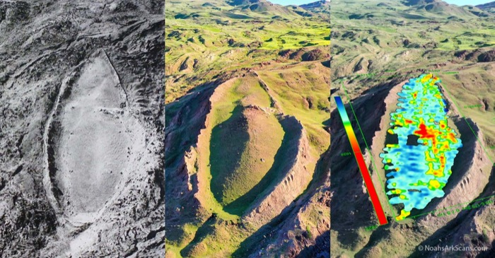
TOP PHOTO: The Durupinar formation as photographed in 1961, 2021, and with a GPR scan overlaying the site. (credit: Discovered Media/NoahsArkScans.com)


